
A good marker of being an adult is when you find yourself regretting the lack of attention you paid in one class or another in grade school. In my case, sometimes it’s Earth Science, and I really did pay quite a bit of attention in that class! But geology was never really my thing, so I just kinda got through it. And now, I notice things about the world and I wonder how they got to be that way. Here’s a good case in point from my neck of the woods. This image (screen-captured from Google Maps, thanks, Google) is Chautauqua Lake in Western New York’s Chautauqua County.

Chautauqua Lake is a big lake, about seventeen miles long and two miles wide at its greatest width. Like the Finger Lakes, it was formed by glacier activity, but the glacier activity that formed Chautauqua Lake was actually different than what formed the Finger Lakes, so Chautauqua is not considered a Finger Lake for this reason. (Plus it’s a hundred miles away from the nearest Finger Lake and it faces the wrong direction!)
You can see that right in the middle it narrows to a really short distance, which used to be the only car crossing on the lake, by ferry. We rode that ferry a lot when I was a kid, but quite soon after we got here the lake was spanned by a bridge for what was then NY17, the Southern Tier Expressway, but which is now Interstate 86. Chautauqua Lake is a very popular resort lake, with tons of recreational uses of its waters and lots of cool stuff in the towns surrounding it.
In the picture you can see Lake Erie to the northwest, less than ten miles away. New York is a state of several varied watersheds: the Finger Lakes, for example, all empty into the Lake Ontario watershed (which then feeds the St. Lawrence River to the Atlantic Ocean), and where I live, all streams eventually flow to Lake Erie and then the Niagara River, and so on. Other watersheds further east flow south to the Susquehanna or Delaware Rivers, and thus to the Atlantic; then there are the waters that drain into the Hudson and reach the sea at New York City.
I never really gave it much thought, but I always assumed that Chautauqua Lake emptied into Lake Erie, since it’s so close by; you could walk from Mayville to the Lake Erie shore at Westfield in a couple of hours. It turns out this isn’t the case! There’s a river in Jamestown, NY, called the Chadokoin, which I always thought fed Chautauqua Lake. Turns out the reverse happens: the Chadokoin is the lake’s outflow, and it confluences with another local stream before joining the Allegheny River somewhere south in Pennsylvania. The Allegheny makes a confluence with the Monongahela River in Pittsburgh, famously creating the Ohio River, which then flows southwest to the Mississippi.
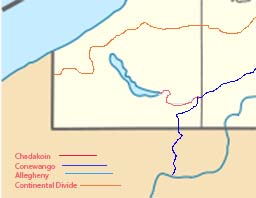
It turns out that there is a divide, called the Chautauqua Ridge, that runs roughly east-west just north of Chautauqua Lake. That divide is all that geology needed to divert waters from the Great Lakes just a handful of miles away, to the Gulf of Mexico, over a thousand miles away. If you’re a drop of fresh water, which side of a hill you fall on determines how long your journey is before you reach salt water again. That amazes me.
Share This Post
Discover more from ForgottenStars.net
Subscribe to get the latest posts sent to your email.